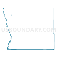
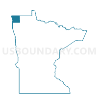
Humboldt Voting District, Kittson County, Minnesota
About
Outline

Summary
| Unique Area Identifier | 602782 |
| Name | Humboldt Voting District |
| County | Kittson County |
| State | Minnesota |
| Area (square miles) | 0.11 |
| Land Area (square miles) | 0.11 |
| Water Area (square miles) | 0.00 |
| % of Land Area | 99.76 |
| % of Water Area | 0.24 |
| Latitude of the Internal Point | 48.92145600 |
| Longtitude of the Internal Point | -97.09446450 |
Maps

Graphs
Select a template below for downloading or customizing gragh for Humboldt Voting District, Kittson County, Minnesota